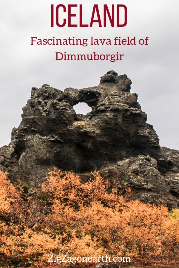
The Dimmuborgir lava field is a surprising area near Lake Myvatn in North Iceland.
The lava formations and the surrounding vegetation will make your imagination wander: cave, pinnacles, apertures and a few imaginary faces…
Below is my guide to explore the Dimmuborgir, Iceland, with maps, photos, hikes and tips.
Note: if you are visiting in Winter, check out my other article about Dimmuborgir in Winter
Before my tips + photos, here are my favorites for Iceland:


My favorite platform to rent a car in Iceland: DiscoverCars

The unmissable boat tour: Whale Watching

Fun activity: Swimming in Silfra Fissure

My favorite places to stay:
- Reykjavik: see best rated hotels – e.g. Vintage Boutique Hotel
- Lake Myvatn: see best rated hotels – e.g. Hotel Laxa
- Vik area: see best rated hotels – e.g. Hotel Vik i Myrdal
Why visit Dimmuborgir in Iceland ?
What is Dimmuborgir?
There are many lava fields in Iceland, but none of them are like Dimmuborgir located near Lake Myvatn. The formations you can admire in that field are intricate and have triggered the creation of many stories with elves, trolls and other mystical creatures.
This was one of my favorite destinations in Iceland and it ended up in my 10 best landscapes list and my top 5 things to do in Myvatn.

Geology of Dimmuborgir Iceland
How were the lava formations of Dimmuborgir formed?
They are thought to be the remains of a lava tube which formed above a lake about 2300 years ago, trapping the water. As it began to cool, the reservoir estimated to have been 10 meters deep, was released, leaving only those shapes created by steam. These rock formations are completely unique (only known similar feature is off the coast of Mexico under water).


What does Dimmuborgir means?
The name translates to “Dark Castles” or “Dark Cities”.
It is due to the tall shapes of dark lava. It kind of look like a city for fairy-tale creatures. But it is also due to the folklore that this area is a gate to hell.
More photos after the planning tips.
PLANNING TIPS & Map – Dimmuborgir Iceland
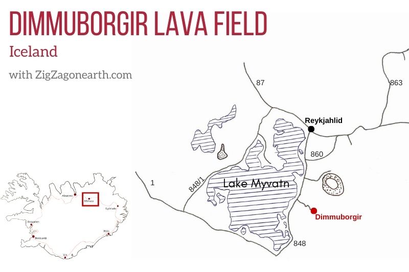
Dimmuborgir Location – Map
- In North Iceland
- East shore of Lake Myvatn, on the Diamond Circle
- Below is a map to help you get oriented and locate the Dimmuborgir lava field:
All my favorite locations are included (with GPS coordinates, map of region and planning tips) in my travel guide eBook to help you easily plan your Iceland road trip (for 5 days, 7 days, 10 days, 14 days…)
Plan your dream trip to Iceland with my guides!
- 8 easy-to-plan maps
- 100+ pre-selected locations
- GPS coordinates
- Useful planning tips
- 130+ large photos
- 2 easy-to-plan maps
- 30 stops, 10 detours
- GPS coordinates
- Useful planning tips
- 70+ large photos
How to get to Dimmuborgir – self-drive
- Akureyri to Dimmuborgir = 1h10 drive
- Egilsstadir to Dimmuborgir = 2h10 drive
- From Reykjahlíð, continue on the Ring Road for approximately 5 km (South shore of Lake Myvatn, towards Akureyri), and then turn left on the road to Dimmuborgir for approximately 1.5 km until you reach the parking. The crossing is well indicated
Need to rent a car in Iceland?
My tips:
- Compare prices on my favorite platform: Discovercars.com – one of the best rated comparison sites!
- Prefer a compact car for the narrow streets in villages
- Consider their full coverage option – it for peace of mind!
- Book early to have a large choice of vehicles!


Visiting Dimmuborgir Myvatn
- Price – It is free of charge, although donations are welcome.
- Walking – Paths are indicated at the entrance (and listed in the section below). Some are paved and other just trails
- How long to visit Dimmuborgir – walking paths vary from 10min to 3 hours. None are very difficult. With 1h you can already see a lot
- Amenities: café near the entrance and toilets (200kr)
- In Winter, the Yule lads is another attraction of Dimmuborgir
- It is a very touristic place, so I recommend going early or late afternoon to enjoy it almost by yourself
- Do not climb the lava formations, stay on the paths!
- And check out my complete article on what to wear and pack for Iceland to stay warm and comfortable
Where to stay nearby – Dimmuborgir Guesthouse
I recommend to stay one night around Lake Myvatn. There is so much to see and enjoy.
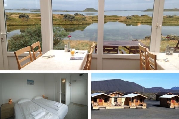
Nearby is the Dimmuborgir Guesthouse, one of my favorite places to stay in Iceland (I booked myself and paid entirely for my stay). Right next to the lake and with the Hverfjall crater in the background… perfect! – check out more photos and book
Otherwise checkout the best rated accommodations in the area.
Otherwise:
- you can stay at Egilsstadir before or after your visit to Myvatn (connection with East Fjords) – see best rated accommodations
- or you can stay at Akureyri, the capital of the North to explore the region – see best rated accommodations
Find more tips in my article about Where to stay in Iceland
The walking paths – Dimmuborgir Hiking Map
Here is a picture of the Dimmuborgir map with all the hiking trails for you to choose. The parking area and entrance is at the top of the picture, above the white trail.

- Small circle (white) – 570 meters – 10-15 minutes takes you to the Borgarskora channel and some of the main features
- Big circle (yellow) – 840m – 15-20 minutes takes you to Hallarflöt (Hallar place), a small grassy area surrounded by lava pinnacles and rock formations near the gate and further formations
- Church circle (Kirkjuhringur – red) – 2.3 km – 1h takes you to the most famous feature: the church
- The crooked path (Krokastigur): – 2km – 1.5 to 2 hours – Indicated as difficult, it goes through the middle of the field. This is a less flat trail. But the comments I saw said that it was not really difficult.
- The Mellond Circle (Mellanahringur) – 3.4km – 1.5 to 2 hours takes you to sand filled lava and sand meadows
- Dimmyborgir-Hverfjall-Storgja – 8km, 2 to 3 hours is a longer hike going out of the Dimmuborgir
Don’t worry you won’t get lost!

The paths close to the entrance are paved.

However, they are not further away.
Please respect the trails!
Have a look at one of the Dimmuborgir walking trails below:

I took the Church path and the yellow portion between both ends of the Church path. I took me 1h30 walking very slowly. Most interesting features are close to the gate. I enjoyed the walk but some might say that it is not worth the walk, just for the church.
Entrance & the most visited Dimmuborgir Lava Field area
Entranceand orientation dial
At the entrance you can have a view of the field from above and more explanation thanks to the orientation table.


Near the carpark you can also get great views of Lake Myvatn

Main features
Not far from the entrance, and along a well-maintained path are some impressive features with few holes.
So even if you don’t have the time or the capacity to hike around, you can already see some great lava formations!
It is only a 10min walk return in Summer (a bit longer in winter with the snow)


I don’t drink coffee 

But I also like other drinks and sweets!
Do you like the free content you find on my blog? All my tips and practical information, without intrusive advertising…

Dimmuborgir Lava Formations – the church and more
But if you take one of the longer walking trails, you can discover more…
The Dimmuborgir Church
The most famous of these formations is “The Church”. And as you can see on the picture below, it is clear why this name was chosen for the feature. This is a cave open at both ends and it has a dome-like ceiling.


The Church is at the other end of the field compared to the other features above. In between the path winds in the midst lava. The formations are less interesting, but the walk is quite relaxing.


Views of crater of Hverfjall
One of my favorite point of views was on the yellow path between both ends of the red path (church walk) as you get vegetation, formation and the Hverfjall volcano crater that I later climbed.


Plan your trip to Iceland this Summer:
Dimmuborgir in Winter
Dimmuborgir remains accessible in Winter. However the longer trails are hard to follow.
The main rock formations close to the gate are easy to admire under the snow.
Learn more on my article about Dimmuborgir in Winter

Legends, movies and TV shows
Folklore
Dimmuborgir is said to connect earth with the infernal regions.
For some, it is believed that Dimmuborgir is the place where Satan landed when he was casted out of the heavens. This is where he created the catacombs of hell.
Mythology of Dimmuborgir – Yule Lads and Trolls
According to Icelandic folklore, Dimmuborgir is the home of a homicidal troll Gryla, her third husband and their sons The Yule Lads. The sons come back in the snow to give children either gifts or rotten potatoes depending on whether they had behaved well or not.
Locals organize festivities in the lava field in December where children can see the Yule Lads

Dimmuborgir in movies and TV shows
- Game of Thrones – Dimmuborgir was used to shoot some scenes of the famous TV-series. It was the background of Mance Rayder’s wilding amp.
- Maybe others but I have not found.
Dimmu Borgir music group
There is also a famous Norwegian symphonic black metal band. It is named after the area.
Want to see other highlights in the area?
- The large volcanic crater of Hverfjall on which you can climb – read article
- The fascinating pseudo-craters of Skutustadir – read article
- The orange geothermal area of Hverir Namafjall – read article
- The lava pillars of Hofdi – read article
- And, a bit further away, the Waterfalls of Godafoss, Aldeyjarfoss and Dettifoss
- Or read my complete article about North Iceland
Planning a trip to Iceland?
Check out my travel guide to help you plan:
Plan your dream trip in Iceland thanks to my guide
- 8 maps to easily plan your itinerary
- 100+ pre-selected locations
- GPS coordinates direct to the carparks
- Tips to make the most of your time
- 130+ original photos to help you choose
And keep track of your own trip!

PREVIOUS LOCATION:
NEXT LOCATION:

Inspired? Share it on your favorite platform!


Hi Claire, I found this blog the MOST useful one for exploring the MyVatn area. Its helping with planning my visit for this area. I was planning on spending 2 days in MyVatn area. Thank you so much for putting this together with so many details and beautiful pictures.
Thanks Indira.
Glad you are finding my blog useful