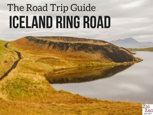
The pseudocraters at Skutustadagigar, Lake Myvatn, are one of my favorite geological features in Iceland.
But those are not real volcanic craters!
Below is my guide to visit the Skutustadir craters, Iceland, with tips, map and photos.
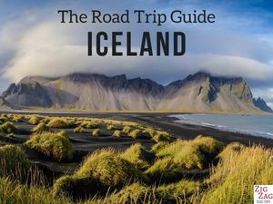
Before my tips + photos, here are my favorites for Iceland:


My favorite platform to rent a car in Iceland: DiscoverCars

The unmissable boat tour: Whale Watching

Fun activity: Swimming in Silfra Fissure

My favorite places to stay:
- Reykjavik: see best rated hotels – e.g. Vintage Boutique Hotel
- Lake Myvatn: see best rated hotels – e.g. Hotel Laxa
- Vik area: see best rated hotels – e.g. Hotel Vik i Myrdal
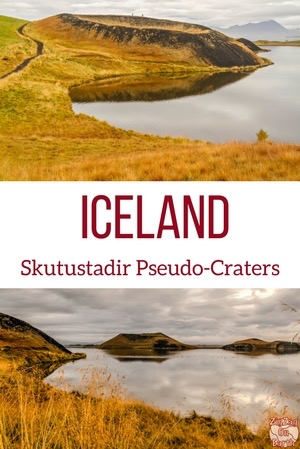
Why visit the Skutustadagigar pseudocraters in Iceland?
Skútustadagígar is the area South of Lake Myvatn around the pond Stakholstjorn where the famous pseudocraters can be found (see next section to understand why they are not real craters).
The Skutustadir Farm is named after an ancient hero called Viga-Skuta and allows us to get up close and climb some of those beautifully shaped pseudocraters.

The Skutustadir pseudocraters made it to my list of the 10 best landscapes in Iceland and my top 5 things to see in Myvatn.
How to pronounce the name?
To facilitate the reading of this article, you can listen to the pronunciation of Skutustadir here.
More photos after the planning tips.
Planning tips & Maps – Skutustadir, Iceland
Skutustadir Location – Map
- North part of Iceland
- South shore of Lake Myvatn,
- Akureyri to Stukustadir = 1h05 drive
- Egilsstadir to Stukustadir = 2h15 drive
- Reykjahlid to Stukustadir = 15min drive
- Below is a map to help you get oriented and locate the pseudocrater walk:

All my favorite locations are included (with GPS coordinates, map of region and planning tips) in my travel guide eBook to help you easily plan your Iceland road trip (for 5 days, 7 days, 10 days, 14 days…)
Plan your dream trip to Iceland with my guides!
- 8 easy-to-plan maps
- 100+ pre-selected locations
- GPS coordinates
- Useful planning tips
- 130+ large photos
- 2 easy-to-plan maps
- 30 stops, 10 detours
- GPS coordinates
- Useful planning tips
- 70+ large photos
How to get to Skutustadagigar
- Very easy to stop along the road that goes around Lake Myvatn
- Large carpark across from the Skutustadir farmers guesthouse
- Accessible to standard cars
- Some organised tours may stop there but you won’t be given time to walk around the pond as the main stop is Dimmuborgir
Need to rent a car in Iceland?
My tips:
- Compare prices on my favorite platform: Discovercars.com – one of the best rated comparison sites!
- Prefer a compact car for the narrow streets in villages
- Consider their full coverage option – it for peace of mind!
- Book early to have a large choice of vehicles!


Visiting Skútustadagígar – the myvatn pseudo-craters
- Large carpark,
- Across the road is a cafe, a gas station and toilets as well as a hotel/restaurant
- And around is a small settlement with a church slightly uphill – Skútustaðakirkja
- The easy walk around the pond can be done in 1 hour (see map below). Some pseudocraters can be climbed, others are protected and cannot be approached
- I think the beginning of the hike has the best views on the West side
- I recommend the use of a fly net in summer. The area is famous for those annoying bugs especially so close to the water. I had some in September but it was bearable.
- This area is also recommended for bird watching
- And check out my complete article on what to wear and pack for Iceland to stay warm and comfortable
Skutustadir Walk Map
Below is the map of the path that takes you all the way around the Stakholstjörn pond to see most of the pseudocraters:

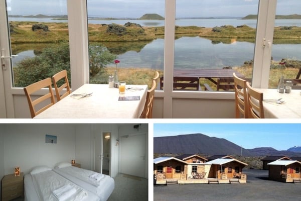
Accommodations around Myvatn
I think Lake Myvatn is a fantastic area to stay for a few days.
The town of Reykjahlid would be a great option to visit the area. Choose one of the lake Myvatn accommodations
The Dimmuborgir Guesthouse is one of my favorite places to stay in Iceland (I booked myself and paid entirely for my stay).
Right next to the lake and with the Hverfjall crater in the background… perfect! See more photos and check availability
Otherwise:
- you can stay at Egilsstadir before or after your visit to Myvatn (connection with East Fjords) – see best rated accommodations
- or you can stay at Akureyri, the capital of the North to explore the region – see best rated accommodations
And find more tips in my article about Where to stay in Iceland
Walking up the first Lake Myvatn pseudocrater
I started the walk around the pseudocraters early morning I was lucky that the wind was down and got rewarded with beautiful reflections.

The first crater you encounter can be circled. See the people below, it gives you an idea of the size of the pseudocrater:

From the top of 2 pseudocraters, you get nice views of the area and sometimes the company of sheep.


The geology behind the Skutustadir pseudocraters – formation
These pseudocraters were formed around 2,300 years ago in the eruption of Ludentaborgir and Threngslaborgir.
Here is the information I found at the Myvatn visitor center where they have very nice displays:
“The planet Mars has recently been found to harbor a large groups of craters that seem to have formed by steam explosions as glowing hot lava flowed over frozen ground. Such “pseudocraters” from on Earth as lava runs over wet sediment or into the sea. Most of Earth’s pseudocraters are in Iceland and they are rare elsewhere. Scientific interest in them has increased after the Mars discovery. The pseudocrater by lake Myvatn are amongst the largest and most beautifully shaped on Earth.
The Myvatn pseudocraters were formed as lava entered a large lake (a precursor of Lake Myvatn), trapping its wet sediment underneath. First, many eruptions take place and a platform of fine-grained material is built up. Later, a few eruption vents take over, the water supply diminishes, and well-shaped crater cones develop on top of the platform. The molten lava moves like a thin sheet inside a stationary crust. The lower crust breaks and the hot lava makes contact with the water-logged sediment underneath triggering violent steam eruptions. The lava continues to flow inside the crust envelope and feeds the steam eruptions.
Now the craters are covered by grass because midges fertilize the soil when they die.”
I don’t drink coffee 

But I also like other drinks and sweets!
Do you like the free content you find on my blog? All my tips and practical information, without intrusive advertising…

Walking along the Stakholstjorn pond
After that I walked down and continued on the path along the pond. Apart from the flies this is a very enjoyable walk. However, the first part had the best views as you can see in the pictures.


Note: If you don’t want to book everything yourself, consider booking a Self-Drive Tour Package (see my article to help you choose)
Plan your trip to Iceland this Summer:
Skutustadir craters in Winter
The first pseudo-craters of Myvatn remain accessible in Winter.
You cannot do the entire loop. walking, but the path and staircases to get on top of the first ones are easy to walk.

The view is just very different: the pond is covered in snow and the landscape is all black and white.
See my article about Myvatn in Winter

And here is a view of the Skutustadir church:

Want to see other highlights in the area?
- The large volcanic crater of Hverfjall on which you can climb – read article
- The crazy lava formations of Dimmuborgir – read article
- The orange geothermal area of Hverir Namafjall – read article
- The lava pillars of Hofdi – read article
- And, a bit further away, the Waterfalls of Godafoss, Aldeyjarfoss and Dettifoss
- Or read my complete article about North Iceland
Planning a trip to Iceland?
Check out my travel guide to help you plan:
Plan your dream trip in Iceland thanks to my guide
- 8 maps to easily plan your itinerary
- 100+ pre-selected locations
- GPS coordinates direct to the carparks
- Tips to make the most of your time
- 130+ original photos to help you choose
And keep track of your own trip!

Want to see more of Iceland’s beauty?
PREVIOUS LOCATION:
NEXT LOCATION:

Inspired? Share it on your favorite platform!


Hi Claire
Thank you for the details and the map ! Beautiful pictures and helpful article ! I have a few questions:
1. Is it easy to figure out which pseudo craters can be climbed and which are protected ?
2. Does the walk around lake Stakholstjorn take an hour without climbing psuedocraters ?
3. If we climb 1-2 pseudocraters, how long will the loop around lake Stakholstjorn take?
4. The west side is the first parking lot near Kirkjumyn ?
Thanks in advance !
Indie
Hi Indie
1. Yes it is is, the paths are clear
2. Depending on how many pictures you take 🙂 1h with the climbing (they are not tall)
3. 1h / 1h1(
4. yes
THANK YOU ! Really appreciate all the details in your blog.
Thanks for the map – verrry helpful!