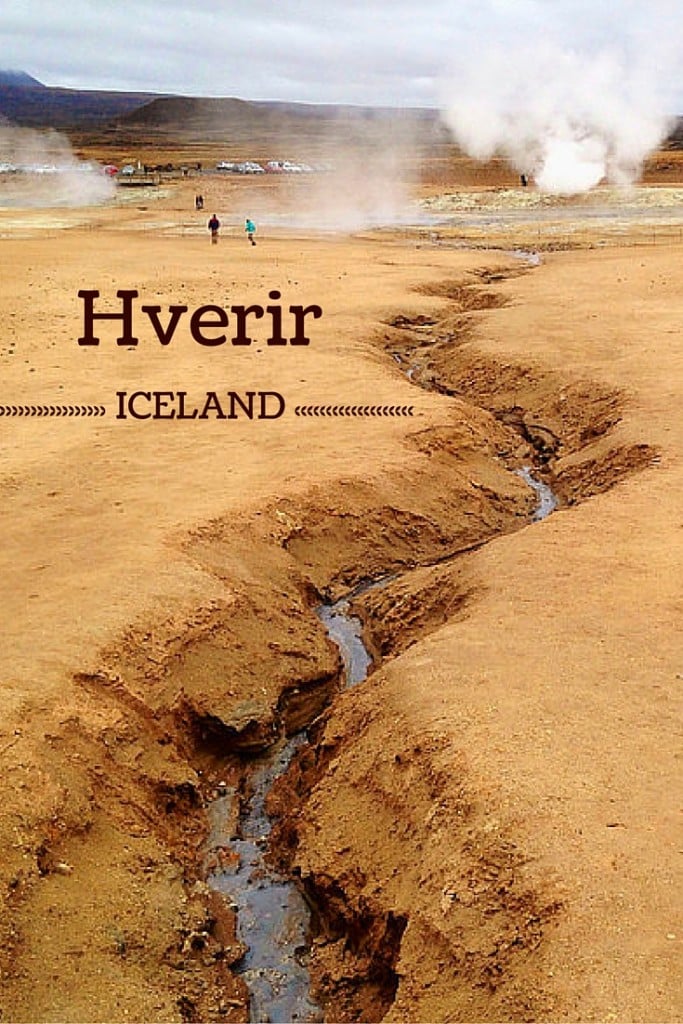
Hverir Iceland is one of the most out-of-this-world sites on the island, where you feel connected to the power of the planet.
At the foot of the Namafjall volcanic mountain, the Namaskard geothermal area displays:
- fumaroles,
- large mud pools,
- steam vents
- and a bare orangy-red landscape.
Below is my guide to help you plan your visit with map, tips and photos.
Before my tips + photos, here are my favorites for Iceland:


My favorite platform to rent a car in Iceland: DiscoverCars

The unmissable boat tour: Whale Watching

Fun activity: Swimming in Silfra Fissure

My favorite places to stay:
- Reykjavik: see best rated hotels – e.g. Vintage Boutique Hotel
- Lake Myvatn: see best rated hotels – e.g. Hotel Laxa
- Vik area: see best rated hotels – e.g. Hotel Vik i Myrdal
What is Hverir a.k.a. Namafjall a.k.a Namaskard?
Hverir is a geothermal area at the foothill of Namafjall, not far from Lake Myvatn.
Features include colorful sulphurous mud springs, steam vents, cracked mud and fumaroles.
It is also called Hverarönd or Namaskard.
A picture is worth a thousand words:

Some say that compared to Wai-o-tapu in New Zealand or Yellowstone it is rather average but personally, I disagree.
I have not seen Yellowstone, but I have visited Wai-o-tapu. It does have many geothermal features with intriguing colors, but the surroundings are a lush forest.
Although there is more to see, I think Hverir and its bare landscape makes the experience surreal which is what I love. If it weren’t for the other tourists, I would have felt like I had landed on another planet.
This is why it is one of my top 5 places to visit in Myvatn and one of my favorite stops on the Ring Road.
Namaskard geothermal area heat map

At the Hverir site, there is this map on which are indicated the areas with high temperature. In light pink is the Krafla fissure system and in hot pink are the hot springs, including Hverir.
Many more photos after the practical info and planning tips.
How to pronounce Hverir
To facilitate the reading of this article, you can listen to the pronunciation of Hverir here.
Planning Tips & Map – Hverir Iceland
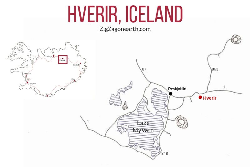
Hverir Location
- Located in North Iceland (see my guide about North Iceland)
- Right by the Ring Road, 6km East of Lake Myvatn and the town of Reykjahlíð – easy to access on your Iceland Road trip
- The Hverir parking is right after the mountain pass on the south side of the road – it is quite large
- You can’t miss it, it is well indicated
- Below is a Map to help you generally locate Hverir:
All my favorite locations are included (with GPS coordinates, map of region and planning tips) in my travel guide eBook to help you easily plan your Iceland road trip (for 5 days, 7 days, 10 days, 14 days…)
Plan your dream trip to Iceland with my guides!
8 easy-to-plan maps.
100+ pre-selected locations.
GPS coordinates.
Useful planning tips.
130+ large photos
2 easy-to-plan maps.
30 stops, 10 detours.
GPS coordinates.
Useful planning tips.
70+ large photos
How to get to Hverir / Namaskard
- If you are visiting North Iceland and the Myvatn area, I strongly recommend renting your own car. This gives you the freedom to visit all the locations you are interested in.
- Otherwise most group tours around the Ring Road do stop at Hverir
- To plan your trip, check out my article about how to rent a car in Iceland and about driving in Iceland
Need to rent a car in Iceland?
My tips:
- Compare prices on my favorite platform: Discovercars.com – one of the best rated comparison sites!
- Prefer a compact car for the narrow streets in villages
- Consider their full coverage option – it for peace of mind!
- Book early to have a large choice of vehicles!


Accommodations near Hverir
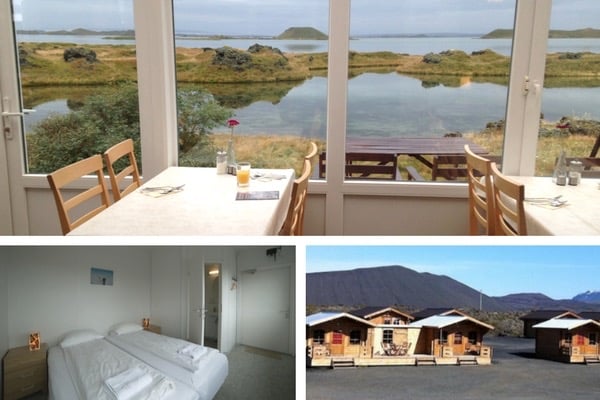
Lake Myvatn, with the town of Reykjahlid, is a great option to visit the area – Check out the Lake Myvatn accommodations
I stayed at the Dimmuborgir Guesthouse (I booked myself and paid entirely for my stay) – it is right next to the lake and with the Hverfjall crater in the background… perfect! Check out more photos and book
Otherwise:
- you can stay at Egilsstadir before or after your visit to Myvatn (connection with East Fjords) – see best rated accommodations
- or you can stay at Akureyri, the capital of the North to explore the region – see best rated accommodations
Find more tips in my article about best places to overnight in Iceland
Where to stay in Iceland?
My favorites:
- Reykjavik, capital city: see best rated accommodations – or my article on where to stay
- Selfoss, between Golden Circle and South Coast: see best rated accommodations
- Vik, near waterfalls and glaciers: see best rated accommodations
- Höfn, gateway to the East fjords: see best rated accommodations
- Egilsstadir, between fjords and North Iceland: see best rated accommodations
- Reykjahlid, for the wonders of Lake Myvatn: see best rated accommodations
- Akureyri, capital of the North: see best rated accommodations
- Grundarfjordur, on the Snaefellsnes Peninsula: see best rated accommodations

Visiting the Hverir geothermal area – tips
At the site entrance, you can see a map of the site with the walking trails:

Hverir Parking
- Large parking lot with easy access from Road 1
- From the parking area there is a short flat loop that leads you close to various geothermal features
Hverir Price and Opening hours
- Parking for a small fee
How long to visit Hverir
The ground loop can be done in just half an hour or you can spend time admiring the bubbles in the mud pool and stay for an hour.
With the Namajsfjall loop, plan 1h30
However, next to the mud pool, it is advised not to stay longer than 1 hours because of the sulphur
The Iceland Sulphur – Smell at Hverir
Beware of the sulphur smell, that resembles rotten eggs.
This is due to the geothermal activity (it is also why hot waters at the tap can also smell like sulphur).
Note that although I suffer from allergies and all, I had no special difficulties while visiting Hverir.
And Check out my complete article with detailed suggestions and tips on what to wear and pack for Iceland to stay warm and comfortable
Exploring the Namafjall geothermal area
Hverir is not a big site but offers many features very close to each another. It is at the foot of a beautiful dark mountain.
Below are some wide shots of the scenic area, its bare landscape and the fumes emanating from the fumeroles.

Some impressive cracks are everywhere on the land creating interesting photographic effects:

I think the shot below is my favorite (equal with the cracks above). I love the contrast of the blue-gray mud pools with the dark orange of the mountain in the background. Surreal!

A lot of fumes! But do not worry that much, look at the next pictures and you will see that they actually area are concentrated and not in the whole area:

The first time I sent the picture below to my mom, she freaked out! She was already worried that I was in Iceland with all those volcanoes but then she became scared that I would be swallowed by the Earth. This crack was actually not that big 🙂

I don’t drink coffee 

But I also like other drinks and sweets!
Do you like the free content you find on my blog? All my tips and practical information, without intrusive advertising…

Hverir Mud Pools
By the parking you can walk to the viewing platform or down to the mud pools. They are quite big and very active.


One of the great things to do in geothermal areas is to photograph some of the features up close. Especially the mud pools which sometimes, create crazy shapes:
Like a heart… (great timing, don’t you think?)

Or its side view…

The small cracked mud bubble inside the cracked hole:

You must have realized it by now, I love photographing cracked surfaces… So here is a last one!

I love that spot so much, that I want to share other sites with more photos:
Extra photos of Hverir hot springs
Because I love the place so much, I am sharing a few more photos of Hverir. I hope you are enjoying them.


More photos by other photographers:
- Hverir photos by Volcanic springs
- Hverir photos with snow on Namafjall by Iceland for 91 days
Plan your trip to Iceland this Summer:
Namafjall Hike
Past the mud pools there is a track that goes up the mountain (see photo below), then goes along the ridge of the mountain and goes down on the other side of the area.
The left side is the steepest with some slippery sections. So, it could be better to ascend on the right side and come back that way too.

Other attractions near Hverir
Consider visiting:
- Grjotagja – the cave filled with hot water – see article
- Myvatn Nature Baths – see article
- Hverfjall – a beautiful crater where you can walk on the rim – see article
- The Leirhnjukur geothermal area that looks quite different with the steaming lava rocks – see article
- And much more…
Find them in my eBooks:
Plan your dream trip to Iceland with my guides!
8 easy-to-plan maps.
100+ pre-selected locations.
GPS coordinates.
Useful planning tips.
130+ large photos
2 easy-to-plan maps.
30 stops, 10 detours.
GPS coordinates.
Useful planning tips.
70+ large photos
Hverir in Winter
As the field is along the Ring Road, it remains easily accessible in Winter.
The contrast of the boiling mud with the snow is impressive.
You can walk around the area easily as the heat melts the snow.
It is darker, less orange, but still a unique place to stop!

Want to see more of the best Iceland has to offer?
- Tips to plan your Iceland road trip – read article
- Tips to rent a car and drive around Iceland – read article
- Itinerary suggestions – read article
- 45 Most beautiful landscapes in Iceland in pictures – read article
- The best stops on the Ring Road – read article
- The best locations off the beaten path around Iceland – read article
- 21 Most beautiful waterfalls in Iceland – read article
- Top 5 places to see around Myvatn – read article
- The 5 most beautiful black sand beaches in Iceland – read article
- The Golden Circle – read article
- The Snaefellsnes peninsula – read article
And keep track of your own trip!

PREVIOUS:
NEXT:

Inspired? Share it on your favorite platform!


