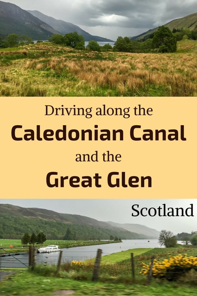
Cutting Scotland in half, the Caledonian Canal is a water way connecting the Eastern and Western coast from Loch Linnhe to Loch Ness over 97 kilometers (60 miles). It connects a series of lochs located in the geological fault of the Great Glen.
The canal can be enjoyed on a drive, on a cruise or by hiking the famous Great Glen Way.
Below are a video and photos of the drive.
Before my tips + photos, here are my favorites for Scotland:


My favorite platform to rent a car in Scotland: DiscoverCars

The unmissable boat tour: Seal spotting on Loch Linnhe from Fort William

My favorite excursion from Edinburgh: Glenfinnan and Glencoe

My favorite places to stay:
- Edinburgh: see best rated hotels – e.g. Balmoral Hotel
- Glencoe: see best rated hotels – e.g. The Glencoe House Hotel
- Portree: see best rated hotels – e.g. The Cuillin Hills Hotel
- Inverness: see best rated hotels – e.g. Kingsmills Hotel
Caledonian Canal drive – Video
The Caledonian Canal is a 100km long waterway connecting the Scottish Western and Eastern Coasts. Boats have to go through 29 locks to make it all the way (including the 8 at Neptune’s staircase). It was constructed along the Great Glen Fault by Thomas Telford in the beginning of the 19th century, created a connection over one third of the way between loch Lochy, Loch Oich and Loch Ness.
Let’s start with a short video. Sadly, on the day I drove along the Caledonian Canal it was pouring rain (this is Scotland after all, and I have been quite lucky the rest of the time), so I have not filmed and photographed as much as I normally do. But it still can give you an idea.
PLANNING TIPS – Caledonian Canal and Great Glen Scotland
Getting to the Caledonian Canal Scotland
- The Canal starts near Fort William on the West Coast (3h from Glasgow and 3h30 from Edinburgh)
- And ends in Inverness on the East Coast (3h15 drive from Glasgow or Edinburgh) … or the other way around
- It is a nice road to add to your Scotland road trip. Check out my travel guide to help you plan your itinerary:
Plan your dream trip in Scotland with my guide!
- 15 maps to easily plan your itinerary
- 170+ pre-selected locations
- GPS coordinates direct to the carparks
- Tips to make the most of your time
- 170+ original photos to help you choose
Driving the Great Glen Scotland
- If staying on the main road A82 all the way, it will take you 1h45 without stopping.
- The road crosses several towns along the way.
- Another option is to cruise on the Caledonian Canal
- Or for the more courageous you can hike the Great Glen Way (79mi, 117km)

Need to rent a car in Scotland?
My tips:
- Compare prices on my favorite platform: Discovercars.com – one of the best rated comparison sites!
- Prefer a compact car for the single-lane roads
- Consider their full coverage option – it for peace of mind!
- Book early to have a large choice of vehicles!

Accommodations
- At one end you can stay at Fort Williams – Check out the best rated accommodations
- At the other end, you can stay at Inverness – Check out the best rated accommodations
Neptune’s Staircase at the end of the Caledonian Canal
Near Fort William, Loch Linnhe connects to the Caledonian Canal through a series of 8 locks called Neptune’s Staircase. You have to be very patient to cross them all as it takes 90 minutes. The system lifts boats 20 meters and was built between 1803 and 1822!!!
I was lucky that a boat was going through them while I was there, I was able to see inside the locks’ machinery and check out the process of crossing.


I don’t drink coffee 

But I also like other drinks and sweets!
Do you like the free content you find on my blog? All my tips and practical information, without intrusive advertising…

A82 detour
After that you can either take the small road B8004 along River Lochy or stay on the main road A82 that gets away from the canal, for a little while. Because of the rain, we stayed on the main road.
And we were rewarded with spectacular views of the mountains around Ben Nevis.


Along Loch Lochy
A82 then reached Loch Lochy. I think with a better weather, the views must be great. It is 15km long (59 miles) and roughly 1 km wide (0.6 miles)


The Laggan Locks separate Loch Lochy from Loch Oich:

Loch Oich in the Great Glen
After the very long Loch Lochy where the road is on the East coast, you cross the river and drive around Loch Oich on its West side. Oich is a small loch with rich wildlife. It is part of the Great Glen Fault.


At the Northern end of Loch Oich, the road crosses the river Oich. Here is a photo of the loch looking South.

And along Loch Ness
After that the road goes slightly away from River Oich before reaching the last part of the Caledonian Canal and Great Glen, the famous Loch Ness. Check out more photos of Loch Ness and discover Urquhart Castle.


Ending in Inverness, Scotland
And the drive ends in Inverness, a beautiful town by the shore.
Here you can walk around the historical town, enjoy the river and visit the castle.

Want to see more of the best Scotland has to offer?
- Most beautiful landscapes in Scotland – read article
- Best things to do in Scotland – read article
- Best Scotland destinations – where to go? – read article
- Best Scottish Castles – read article
- Most beautiful lochs in Scotland – read article
- Most scenic drives in Scotland – read article
- The magnificent Isle of Skye – read my best-of guide
- The magnificent Wester Ross region – read article
And keep track of your own trip!

Want to see more of SCOTLAND?
PREVIOUS:
NEXT:

Inspired? Share it on your favorite platform!


