One of the most fascinating site in Iceland is the hidden canyon of Sigöldugljúfur.
Located in the Central Highlands (4WD required), the Valley of the Tears is a colorful canyon full of waterfalls!
Below is my guide to help you plan your visit: access, tips, map, photos…
Before my tips + photos, here are my favorites for Iceland:


My favorite platform to rent a car in Iceland: DiscoverCars

The unmissable boat tour: Whale Watching

Fun activity: Swimming in Silfra Fissure

My favorite places to stay:
- Reykjavik: see best rated hotels – e.g. Vintage Boutique Hotel
- Lake Myvatn: see best rated hotels – e.g. Hotel Laxa
- Vik area: see best rated hotels – e.g. Hotel Vik i Myrdal

Why visit the Sigoldugljufur canyon?
In my opinion, this is one of the most mesmerizing landscapes in Iceland.
It has it all:
- The remote location and effort to access it
- The colors with black volcanic rock, green grass and turquoise glacier water
- The mountains in the distance
- as well as tens of waterfalls, which is why it is also called Valley of the tears.

The canyon used to be filled by the river Tungnaá.
The water from the lake is now forced into conducts to the power plant. But the canyon is still there for our pleasure.
More photos after the planning tips.
Planning tips & Map – Sigöldugljúfur Iceland
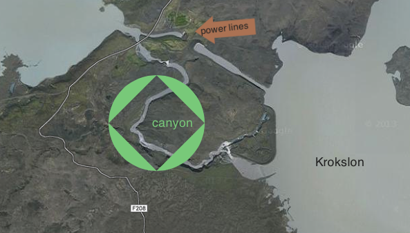
Where is the canyon of Sigoldugljufur in Iceland?
- Off the beaten track, in the Central Highlands
- walking from road F208 (on its northern part)
- Considering the isolation of the place, I am using google map to show you the position of the canyon compare to the road.
- Reykjavik to Stop on road F208 = 2h30
- Vik to Stop on road F208 = 2h30
- North of Landmannalaugar
- Below is an extract from Google Maps with the road, the power lines and the canyon:
This location is included (with tips and GPS coordinates) in my Travel Guide eBook that facilitates the planning of your road trip:
Plan your dream trip in Iceland thanks to my guide
- 8 maps to easily plan your itinerary
- 100+ pre-selected locations
- GPS coordinates direct to the carparks
- Tips to make the most of your time
- 130+ original photos to help you choose
How to get to the Sigoldugljufur canyon?
- 4WD access only
- F208 road normally opens at least between mid-June and mid-September, sometimes longer (opening dates vary)
- If you are not comfortable entering too much of the Highlands in a 4WD, drive from the North via F26 – the track is easier without river crossing.
- Hiking required from the road
Need to rent a car in Iceland?
My tips:
- Compare prices on my favorite platform: Discovercars.com – one of the best rated comparison sites!
- Prefer a compact car for the narrow streets in villages
- Consider their full coverage option – it for peace of mind!
- Book early to have a large choice of vehicles!


Visit tips
- There is a service road leaving from F208, don’t drive there, but you can use it to walk if you don’t want to hike through the lava rocks
- Once you reach the ridge of the canyon, just walk along it – but be careful!
- No amenities at all
- The waterfalls are on the East leg of the canyon, after the bend. The bend is the best viewpoint.
- You can keep walking towards the lake for more waterfalls.
- Dangerous to walk down inside – steep

Closest accommodations
To the South, there is the campsite of Landmannalaugar.
To the North, along F26 you can find a couple of lodges – which can be great to stay and start your drive on F208 early
- Hotel Highland
- Thoristungur Highland Fishing lodge
- Hrauneyjar Highland Center – check out photos and availability
Where to stay in Iceland?
My favorites:
- Reykjavik, capital city: see best rated accommodations – or my article on where to stay
- Selfoss, between Golden Circle and South Coast: see best rated accommodations
- Vik, near waterfalls and glaciers: see best rated accommodations
- Höfn, gateway to the East fjords: see best rated accommodations
- Egilsstadir, between fjords and North Iceland: see best rated accommodations
- Reykjahlid, for the wonders of Lake Myvatn: see best rated accommodations
- Akureyri, capital of the North: see best rated accommodations
- Grundarfjordur, on the Snaefellsnes Peninsula: see best rated accommodations

Hike to Sigoldugljufur
Once you have stopped along road F208, you still have to walk to reach the canyon.
From the small hill, you have a great view of the path, the top of the canyon and the lake.
In the picture below, you can see in the background lake Sigöldulón also known as Krókslón.
It takes around 15min from the road to reach the edge of the canyon and walk up to the waterfalls.

You can stay on the road or venture across the lava.
However be careful.

And then you reach the edge of the canyon!

The famous pictures are of the upper section with the waterfalls.
But don’t skip the lower section! The rocks, slopes and colors are already beautiful.

This is really a dream for photographers!
But please be careful while standing on the edge!


And as you look South towards the bend, you can start seeing some of the waterfalls!

I don’t drink coffee 

But I also like other drinks and sweets!
Do you like the free content you find on my blog? All my tips and practical information, without intrusive advertising…

Sigoldugljufur waterfalls – Valley of the Tears
Keep walking towards the bend, and you slowly will discover the myriads of waterfalls flowing all along the canyon.
This is really unbelievable…

And once at the bend, you see many many more waterfalls appearing, looking like tears falling along the walls of the canyon.

Splendid, don’t you think? It was one of my favorite views in Iceland. I just sat there in awe.
Below is a zoom of those many waterfalls along the steep walls of the canyon:

I know you will want to take a lot of pictures, but take the time to stop and look at the view!

Plan your trip to Iceland this Summer:
Want to see more of the best Iceland has to offer?
- 45 Most beautiful landscapes in Iceland in pictures – read article
- The best stops on the Ring Road – read article
- The best locations off the beaten path around Iceland – read article
- 21 Most beautiful waterfalls in Iceland – read article
- Top 5 places to see around Myvatn – read article
- 5 best Lava Fields in Iceland – read article
- The 5 most beautiful black sand beaches in Iceland – read article
Planning a trip to Iceland?
Check out my travel guide to help you plan:
Plan your dream trip in Iceland thanks to my guide
- 8 maps to easily plan your itinerary
- 100+ pre-selected locations
- GPS coordinates direct to the carparks
- Tips to make the most of your time
- 130+ original photos to help you choose
And keep track of your own trip!

PREVIOUS LOCATION:
NEXT LOCATION:

Inspired? Share it on your favorite platform!


Hi! I was curious how long the commute to Sigöldugljúfur was from Seljalandsfoss. And how long the hike was from parking to the main outlook of sigoldugljufur? any advice or hints? we are going in April. Was not sure what the road conditions would be around this time!
So excited to hear back from you! Thank you so much for your amazing blog. I LOVE IT!!
-Elizabeth
Hi Elizabeth.
Thanks for your comment. I am glad your are enjoying my blog.
The way to this canyon is via an F-road (F208). Those roads are opened only during summer months (I added a note in this post). It normally opens during the month of June depending on conditions. So I am sorry to say that in April you won’t be able to get there.
Enjoy your rip!
Claire
Hi!
I will be there in July.
When I look at this place in Google Earth, I see tire tracks leading from F208 to canyon.
Is it possible to drive this path with 4WD car? Or should I leave my car somewhere on the F208?
Hi Adam
Yes there is a track going towards the canyon. You can see it in 2 of the pictures under ‘How we discovered this hidden treasure’
Our driver first said he was not allowed to take it. Later he drove it to come and take us. So I am not sure if it is allowed to drive it or not… Sorry.
Enjoy your trip!
Claire
According to this map (Map – Já.is) :
http://en.ja.is/kort/?x=494005&y=406067&z=9&type=aerial
there is a road.
Junction with F208 coordinate: 64° 9.352’N, 19° 8.305’W (Google Maps: 64.156000, -19.139553)
I will try with Hyundai Tucson. Thanks
It is not allowed to for tourists to drive to this spot. However, it is about a 1-20 mins short walk from F208. You can park your car on the roadside. Trust me, it is worth the walk. Amazing views.
Amazing blog with great pictures! Learn so many amazing and helpful things about Iceland. I am really glad you have decided to share with us.
Hi Claire,
My husband and I will be going to Iceland in June and are planning (weather permitted) and driving a similar route. Could you tell me about how long you stayed at each destination and a guesstimation of the hiking times and distances? Any advice would be welcome. Thanks!
Hi Kristin
If you talk about dirving Road F208, it takes all day to drive (an requires good 4WD skills).
You could break for the night at the camping ground in Landmannalaugar.
Note that the road opens some time in June, the date varies depending on weather conditions.
Plan at least 2h at the canyon and 2h in Landmannalaugar.
If you are talking about your entire Iceland trip, please refer to my suggested itineraries article: https://www.zigzagonearth.com/visit-iceland-itinerary/
I wish you a wonderful trip!
Last summer (thanks to Claire’s blog and advice) I found Sigöldugljúfur canyon. It is really peopleless and amazing place. Thank You Claire 🙂
The easiest way to find it:
On the left side of road F-208 (going from north to Landmannalaugar) there is side road (dirt) with standard road sign “no entry for all vehicles”. This is the best place to stop. Leave the car on the main road (you will find something like parking space – big enough). The side road takes you exactly to the main branch of the canyon (10 – 15 minutes of walk). Of course you don’t have to use the road. You can go across the lava field. It is shorter and faster but less comfortable. You can take this way returning.
Hi
I did some research about this area and found your post. We are in Iceland with 3 littlw kids and need the stroller (a good one). I the ground accessable for a stroller or really “wild”?
Thank you so much
Hi
There is a track for the government vehicles which is a good option. It is longer than cutting through the lava field but the ground will be easier.
Have a great trip!