Let’s discover one of the most famous features on the Isle of Skye: Kilt Rock and the Mealt Falls.
The abrupt and unique sea cliffs are a fun an interesting stop.
Below is my guide to enjoy the Kilt Rock walk, the waterfalls of Mealt and Lealt and other places to visit in the area – Facts, Map, Tips, Photos…
Before my tips + photos, here are my favorites for Scotland:


My favorite platform to rent a car in Scotland: DiscoverCars

The unmissable boat tour: Seal spotting on Loch Linnhe from Fort William

My favorite excursion from Edinburgh: Glenfinnan and Glencoe

My favorite places to stay:
- Edinburgh: see best rated hotels – e.g. Balmoral Hotel
- Glencoe: see best rated hotels – e.g. The Glencoe House Hotel
- Portree: see best rated hotels – e.g. The Cuillin Hills Hotel
- Inverness: see best rated hotels – e.g. Kingsmills Hotel
Why visit Kilt Rock and the Eastern Cliffs of the Isle of Skye?
The Trotternish peninsula, North of the Isle of Skye, is full of stunning places to see, especially sea cliffs.
The Staffin Ecomuseum identifies several of those sites, with numbers and maps.
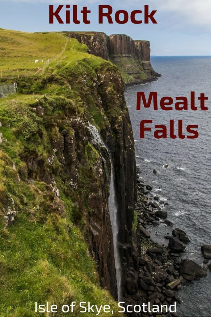
Kilt Rock is a favorite for tourists because of the Kilt-like shape of the basalt column and its waterfall dropping into the sea, the Mealt Falls.
But there is actually more to see…

Below a short video introducing the sea cliffs on the Eastern shore of the Isle of Skye – Kilt Rock Skye, Mealt Falls and Lealt Falls – get a virtual tour!
More photos after the tips to help you plan your trip.
Planning Tips & Map – Kilt Rock Skye and Eastern cliffs
How to get to the Isle of Skye
- The Isle of Skye is accessible by road via the Skye bridge or with the ferry from Mallaig
- The main town is Portree
- Edinburgh to Portree – 4h30 drive
- Find out more about getting to Skye on my Isle of Skye complete Guide
- Worried about driving in Scotland? Check out my article with photos and a video – here
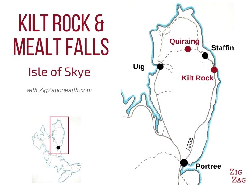
How to get to Kilt Rock and Mealt Falls – Map
- Easy drive from Portree to Kilt Rock carpark
- Another name of the area is Elishader, the name of the village
- Take Road A855 towards Staffin – good road – one lane in each direction
- Portree to Kilt Rock – 15km – 30min drive
- Staffin to Kilt Rock – 2km
- There are other great stops to enjoy on the road and I am introducing them in this article.
- Below is a Map to help you locate Kilt Rock and Mealt Falls:
The locations in this article are all included in my Travel Guides eBooks that facilitate the planning of your road trip in Scotland:
Plan your dream trip to Scotland with my guides!
- 15 easy-to-plan maps
- 170+ pre-selected locations
- GPS coordinates
- Useful planning tips
- 170+ large photos
- 8 easy-to-plan maps
- 60+ pre-selected locations
- Useful planning tips
- 115+ large photos
- GPS coordinates
Visiting Kilt Rock and other cliffs
- Several sites are identified on the Coast from the Old Man of Storr to Quiraing and further North. This area is called the Staffin Ecomuseum. See the map of the sites below.
- No facilities at any of the stops – Public toilets at the Staffin Community Hall
- The view of Kilt Rock Skye and the Mealt Falls is right next to the carpark – not much to walk but you might have to wait for your turn to see it properly.
- This is an island in the North… dress for cold wind!

Where to stay on the Isle of Skye?
- Portree is the main town and the most practical place to explore the island – Check out the best rated accommodations in Portree
- Find out more tips on my Isle of Skye article
Need to rent a car in Scotland?
My tips:
- Compare prices on my favorite platform: Discovercars.com – one of the best rated comparison sites!
- Prefer a compact car for the single-lane roads
- Consider their full coverage option – it for peace of mind!
- Book early to have a large choice of vehicles!


CLIFF 1 – Kilt Rock and Mealt Falls walk & viewpoint
Let’s start with the famous Kilt Rock and its waterfall. It is also called Creag An Fheilidh.
Access & carpark for the Kilt Rock Walk
You will wonder many times before arriving there, if a place is the Kilt Rock carpark because there are other interesting stops (that I am sharing further down) but don’t worry you can’t miss that one, it is well indicated.
The Kilt rock view is easily accessed by everyone as it is very close to the carpark via a well-maintained pathway.
It takes only a couple of minutes of walking on a paved path to reach the view.
However being one of the top things to do in Skye, you will never be alone and might have to wait to reach the fence and get the best unobstructed view.


About the Kilt Rock waterfall a.k.a. Mealt Falls – Facts and photos
The phenomenon you notice first, as you approach the edge of the viewpoint, is the Kilt Rock waterfall.
Here are a few facts:
- Height – The Kilt rock waterfall, the Mealt Falls is a 55-meter free drop into the sea.
- Source – It is fed by Loch Mealt on the other side of the road – you can walk across the road to see it. The loch is 1km in length
- It is fairly rare to see a waterfall dropping into the sea. So, even though there is not much water flowing, the view is quite special.
- Best time – Being on the eastern shore, it is best visited at sunrise
- There is sometimes a bagpipe player in traditional costume near the carpark
- I have searched but have not found what the name Mealt means, sorry.


About the Kilt Rock Viewpoint – facts
The other reason behind the popularity of this place is the shape of the cliff. The vertical basalt columns look like they form the pleats of a pleated Scottish Kilt.
- Height – The cliffs are around 60m (200ft) high.
- Geology – This is a typical geological formation from volcanic activity. It is made of dolerite rock strata in many different colors. This was a natural phenomenon.
- The overall coloring is pinkish red
- The shape is fascinating – it really looks like a kilt with the straight basalt columns and the slightly wider sandstone base
- Sound – plus when a strong wind is blowing, tones can be heard as it enters the man-made holes of the safety fence, creating an organ-like musical instrument

The other viewpoint at the Mealt Falls walk
Most visitors look at the falls and the rock and head back to their car. Don’t do that just yet!
You can also walk to the other side of the walking path for another great view of the sea cliffs.
Below is a picture of the view:

How do you get to the Bottom of Kilt rock and Mealt Falls? Is it a climbing site?
Kilt rock is a climbing site you could enjoy. However, with wind and water it can be treacherous – more info
Climbing is the only way to reach the bottom of Kilt rock and Mealt falls
I don’t drink coffee 

But I also like other drinks and sweets!
Do you like the free content you find on my blog? All my tips and practical information, without intrusive advertising…

CLIFF 2 – Lealt Falls – An Lethallt
A little South of Kilt Rock, I stopped at An Lethallt thinking it was Kilt Rock. Apparently, it is a common mistake.
However, it can be a happy one, as it is a beautiful stop as well.
A short walk takes you from the carpark along a narrow canyon. At the end admire the view over a beach. And when you turn around and come back you realize the point of interest is a waterfall that is actually very close to the road. It is nested in the lush green canyon.
I think this spot deserves a short stop (even just 5 minutes to see the waterfall).
A flat 2 to 3-hour return walk takes you on the diatomite railway to Loch Cuithir for those interested in history and views of the Trotternish ridge.


CLIFF 3 – Tobhta Uachdrach
Not far North from the Old Man of Storr, you will spot a small parking area on the right.
This is Tobhta Uachdrach. From there, on a clear day, you can see the peaks of mainland Scotland.


And if you turn around you have a great view of the Trotternish Ridge and the Old Man of Storr.

CLIFF 4 – Staffin Slip and its beach
After Kilt Rock you can continue driving up to Staffin. Before turning inland towards the magnificent view of Quiraing, turn towards the sea to admire the cliffs from the sea level at Staffin Beach and the Staffin Slipway. Here is what you could see:

The Staffin’s harbour is known as the Slip. It is a great area for fishing, walking or bird watching… as well as enjoying nice views of the sea cliffs.
The original Slipway was built in the early 1900 to allow for the deliveries of food and goods.


Driving in between Kilt Rock and the Isle of Skye eastern cliffs…
On the road between each of the sites, the views of the Trotternish ridge are spectacular. You can also see some strange rock formations…


There is another stop called Rubha nam brathairean or Brothers Point that is a dramatic headland. I seem to have missed it. It is a 1h return walk. The start is at Lay-by on A855 at Culnacnoc – 40m north of The Glenview hotel.
Want to see more? Here are other amazing things to do on the Isle of Skye:
- The Old Man of Storr icon – read article
- The Quiraing viewpoint – read article
- The Magical Fairy Glen – read article
- The sparkling Fairy Pools hike – read article
- The Elgol Boat tour to Loch Coruisk – read article
- Or enjoy my complete article about the best things to do on the Isle of Skye
Planning your itinerary around Scotland? Check out my travel guide:
Plan your dream trip in Scotland thanks to my guide
- 15 maps to easily plan your itinerary
- 170+ pre-selected locations
- GPS coordinates direct to the carparks
- Tips to make the most of your time
- 170+ original photos to help you choose
And keep track of your own trip!

PREVIOUS:
NEXT:

Inspired? Share it on your favorite platform!


