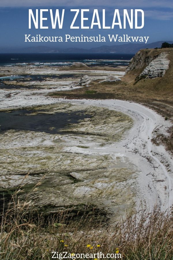
The Kaikoura Peninsula walk walkway is one of the best activities in town, with impressive views from both the bottom and top paths.
Below is my guide to help you plan your trip and enjoy your Kaikoura peninsula walk.
Why do a Kaikoura Peninsula Walk?
If you are stopping in Kaikoura to see the whales or swim with wild dolphins, I recommend blocking half a day to walk around the peninsula, just South of the town:
- It is home to the seal colony of Point Kean
- It offers a walk at sea-level around beautiful white rocks and cliffs
- Or you can head to the top of the cliffs for amazing views of the peninsula, the bays and the mountains.
- You can walk as little or as long as you want, even with just 10min you can have great views
- If you bring binoculars, you may spot dolphins or whales in the distance
Below are 2 of my pictures to show you what I mean.


Video of the Kaikoura peninsula walkway
Below is a short video to help you understand what to expect.
Many more photos after the practical information.
Planning tips and Map – Kaikoura peninsula walkway, New Zealand
Where is Kaikoura located?
- Located in South Island, East coast
- Picton (ferry) to Kaikoura = 2h drive
- Christchurch to Kaikoura = 2h30
- Below is a map to help you locate Kaikoura

Need to rent a car in New Zealand?
My tips:
- Compare prices on my favorite platform: Discovercars.com – one of the best rated comparison sites!
- Prefer a car with enough power for the mountain areas
- Consider their full coverage option – it for peace of mind!
- Book early to have a large choice of vehicles!
- See all my tips to choose and book your car


Start of Kaikoura Peninsula Walkway
- Located in South Island, East coast
- The walk starts from the Point Kean car park, about 5 km south from the town centre
- Easy drive to the carpark – a good stop on your South Island itinerary
- There are no public transport from Kaikoura’s centre
The Kaikoura peninsula is included in my eBooks, to help you plan an unforgettable road trip:
Plan your dream trip to New Zealand with my guides!

- 12 easy-to-plan maps
- 200+ pre-selected locations
- GPS coordinates
- Useful planning tips
- 285+ large photos
- 6 easy-to-plan maps
- 110+ pre-selected locations
- GPS coordinates
- Useful planning tips
- 190+ large photos
Time to Complete the Kaikoura Peninsula Walk
You can walk from 10 min to 3 or 4 hours.
There is a variety of walks possible.
For example , below are some short ones:
- Carpark to Point Kean viewpoint – 5min / 200m
- Point Kean viewpoint to Whalers Bay viewpoint – 25 min / 1.5km
- Whalers Bay viewpoint to South Bay viewpoint – 20min / 1.1km
- South Bay viewpoint to South Nay carpark – 15min / 600m
Other tips
- Free access
- Toilets at the Point Kean carpark and at the South Bay carparks
- Difficulty: If you take the top walk – once you climbed to the top very easy walk. Climb was a little steep but not too long ; If you stay at sea level: it is rockier and not as easy to walk around
- Safety: Always leave some distance between you and the seal: They seem lazy but the can be fast!
- There many information points along the way to point out interesting features.
- Here you can find their very detailed brochure of the Kaikoura peninsula walk

Need to rent a car in New Zealand?
My tips:
- Compare prices on my favorite platform: Discovercars.com – one of the best rated comparison sites!
- Prefer a car with enough power for the mountain areas
- Consider their full coverage option – it for peace of mind!
- Book early to have a large choice of vehicles!
- See all my tips to choose and book your car
Accommodations in Kaikoura
Kaikoura is a great place to spend at least a couple of nights.
The mountains are dropping almost directly into the sea. Plus, this is the best place to see dolphins and whales.
Check out the best rated accommodations in Kaikoura
You can find accommodations at sea level, or others higher with great views.
If you want something really close to the walkway, consider:
- The point B&B – check out pictures and availability
- Futuna rocks motel – check out pictures and availability
- a little further away, above town, I stayed at Barnacle Bills and had a wonderful time – check out pictures and availability

Kaikoura peninsula walkway map & Times
Below is the map you can find at the beginning of the peninsula walkway.
The official walkway is the one at the top of the cliffs:

Walking times
Next to the map the walking times and distances indicated are :
- Carpark to Point Kean viewpoint – 5min / 200m
- Point Kean viewpoint to Whalers Bay viewpoint – 25 min / 1.5km
- Whalers Bay viewpoint to South Bay viewpoint – 20min / 1.1km
- South Bay viewpoint to South Nay carpark – 15min / 600m

Walking options
Option 1 – Short walk – climb to Point Kean viewpoint and back down
Option 2 – Walk the cliff walkway and back the same way (what I did the first time)
Option 3 – Half loop – Sea-level walk at low tide up to Whalers Bay, climb the 130 stairs up the cliffs and come back via the cliff walking track (what I did the second time – It took me 3 hours but with lots of photos and with me being a slow walker) – or you can do the opposite
Option 4 – Long Loop – Sea-level walk at low tide walk along the shore all the way to South point car park and return via the cliffs at higher tide
You can also download the brochure for the walk
Below is a short video of my half loop walk starting on the sea-level and coming back on the cliffs:
Point Kean seal colony
At the beginning of the walk, you can head towards the sea on the large flat area you see in front of you. This is Point Kean.
A seal colony lives in the area, so there is a great chance that you spot some seals resting on the rocks.
However they are wild animals, so I can’t guaranty it…


About the New Zealand fur seals:
- Remember to stay at a distance, their flippers are strong and they can go fast on land even if they don’t look like it!
- They are great swimmers (they are able to cross to Australia)
- They have 2 layers of fur
- They can dive deeper than 250m
- They can dive for up to 10min
- Males are massive around the neck and shoulders while females carry their weight around the lower body
- In Kaikoura they feed in the off-shore canyon. They enjoy lantern fish, squid and octopus
You can read more information on the signs at the carpark.

Best time to see the seals at Point Kean, Kaikoura
They can be seen all year but their numbers vary.
- You can see many males during Winter
- During the breeding seasons (Spring and Summer) they head to larger colonies such as Ohau Point

Short walk to Point Kean viewing platform
If you have a little big more time, you can climb the 5min to the Point Kean viewing platform.
If offers great views of the peninsula and the mountains dropping into the sea.
Below is the start of the Kaikoura peninsula walkway. As you can see there is to way to miss it 🙂

The path is well maintained:

And it offers great views of the mountain plunging into the sea:

Once at the viewing platforms, you can learn more about:
- The summits
- The land
- The geology with the uplifted sediments
- The history

From their you can walk back down to the carpark, or keep walking the peninsula walkway. From there it is easy and rather flat (but not paved).
The cliff walk at Kaikoura peninsula to Whalers Bay
Below are a few pictures of the views that you can have as you walk towards or from Whalers Bay:


View from Whalers bay viewpoint:

About the whales in Kaikoura –
- Some sperm whales are resident
- You can also see migratory whales: Humpbacks, Blue whales…
- They enjoy the feeding ground that is the deep canyon off the coast
Note
If you decide to not complete the cliff walk and use the stairs at this point to go up or down, make sure you walk just a few more minutes South on the cliffs for views of the neighboring bay. It is my favorite!


Staircase at Whalers Bay
From the sea-level walk, the staircase is not well indicated.
Just find the single pointy hill at the end of Whalers bay and head behind it towards the cliff.

It starts as a track and ends as a staircase with 130 stairs.


I don’t drink coffee 

But I also like other drinks and sweets!
Do you like the free content you find on my blog? All my tips and practical information, without intrusive advertising…

Sea level Kaikoura coastal walk – photos
If you opt to walk at sea level, know that:
- There is some walking on rocks and in pebbles. It is not a flat easy path. The pebble sections are particularly tiring
- It is better to do it at low tide (especially for the second half), as some of the points must be walked around close to water and waves can come crashing
- But it allows you to see up close the sculpting of the limestone by the elements – twisted, layered…
Below are pictures of my Kaikoura coastal walk:


Geology of Kaikoura Peninsula – pre and post earthquake
Geological introduction
- The land you are walking on used to be the sea bed.
- 15 millions year ago the earth curst movement, raised them up out of the sea.
- The Kaikoura peninsula used to he an island hundreds of thousands of years ago.
- But gravels rom the mountain filled the sea and it became a peninsula.
Between major earth movement and uplifts the wave shape and erode the land creating platforms.
At the top of the peninsula you are on the oldest platform and at the sea-level you are on the newest.
2016 earthquake
The crust keeps being lifted and it was significantly raised during the last big earthquake in 2016 revealing new land (note you can learn more about it at the Kaikoura museum in town)
Below are photos take before and after – however it is not possible to compare – the tide is different and the new land clearly identified in in the North shore of the peninsula (see difference here)


Other things to do in Kaikoura
Whale and dolphin watching
Not far from the coast of Kaikoura is a very deep canyon underwater.
Therefore whales love coming here, since it is a perfect feeding ground for them.
The top activity to do in Kaikoura is to go whale watching by boat or by plane / helicopter.
Check out the many options
Swimming with wold dolphins
Another unique experience is the opportunity to go in the water once a pod of wild dolphins is found.
It is an experience you will never forget!

Kayaking
Another great way to appreciate how the mountain drop into the sea is to go kayaking and see it as you glide on the water!
And also…
- Watch the seal colonies
- Walk on the beach
- Look for albatross
- Visit the Kaikoura Museum
- …
Want to see more of New Zealand?
- New Zealand North Island vs South Island – read article
- New Zealand in 50 photos – read article
- 20 Best waterfalls in New Zealand – read article
- 15 most beautiful beaches in New Zealand – read article
- Things to do in New Zealand North island – read article
- Things to do in New Zealand South island – read article
- New Zealand hidden gems – read article
- How to plan a New Zealand road trip – read article
- New Zealand 2 week itinerary – read article
Planning a trip to NZ?
Check out my travel guide to help you plan:
Plan your dream trip in New Zealand with my guide!
- 12 maps to easily plan your itinerary
- 200+ pre-selected locations
- GPS coordinates direct to the carparks
- Winter tips to make the most of your time
- 285+ original photos to help you choose
And keep track of your own trip!

Want to see more of NEW ZEALAND?
PREVIOUS LOCATION:
MOTUKIEKIE BEACH PHOTOGRAPHY WONDERLAND
NEXT LOCATION:
SWIM WITH WILD DOLPHINS – old article

Inspired? Share it on your favorite platform!


