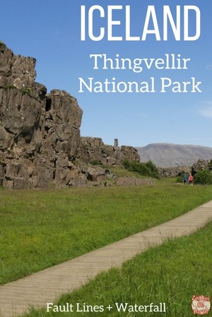
Thingvellir National Park Iceland is one of the most popular places to visit and a Unesco World Heritage site of geological and historical significance.
Here you can discover the Oxarafoss waterfall, Almannagha fault line, Silfra fault line and church, plus enjoy a unique snorkeling experience!
Below is my guide to organize your visit with tips, maps and photos.
Before my tips + photos, here are my favorites for Iceland:


My favorite platform to rent a car in Iceland: DiscoverCars

The unmissable boat tour: Whale Watching

Fun activity: Swimming in Silfra Fissure

My favorite places to stay:
- Reykjavik: see best rated hotels – e.g. Vintage Boutique Hotel
- Lake Myvatn: see best rated hotels – e.g. Hotel Laxa
- Vik area: see best rated hotels – e.g. Hotel Vik i Myrdal
Why visit Thingvellir National Park in Iceland?
Thingvellir (Þingvellir) is a UNESCO World Heritage site of historical (ref 1152), cultural, and geological importance in southwestern Iceland. It is one of the most popular tourist destinations in Iceland with mountains, rivers, lake, waterfalls and fault lines.

Geologically, it is a series of huge fissures in the earth’s crust caused by the rifting of the North American and Eurasian Plates. It created beautiful rock features. The largest fault line, Almannagjá, looks like a canyon and is home to the Oxararfoss waterfall. Some of the fissures are full of clear water. Nikulásargjá, a.k.a. Peningagjá (“coin fissure”), is filled with coins at its bottom. And the Silfra fissure is the one where you can dive.
Historically, it is the site where parliament was established in the year 930 (said to be the founding of the nation of Iceland) and remained there until 1798.
Thingvellir National Park was established in 1928-1930 to protect the remains of the parliament site and was later expanded to protect natural phenomena in the area.
With the Gullfoss Waterfall and the Haukadalur Geothermal area, it is known as the Golden Circle.

More photos and places after the planning tips.
PLANNING TIPS & Maps – Thingvellir Iceland
Where is Thingvellir – Map & Location
- 45 Minutes North East from Reykjavik
- via Road 1 (15km) and the Road 36 (Þingvallavegur for 33km)
- The national park is on the North shore of Þingvallavatn
- For the shorter path to Öxarárfoss waterfall, turn right on Road 361 for 1km. The parking area will be on the right.
- Below is a map to help you get oriented:

All my favorite locations are included (with GPS coordinates, map of region and planning tips) in my travel guide eBooks to help you easily plan your Iceland road trip (for 5 days, 7 days, 10 days, 14 days…)
Plan your dream trip to Iceland with my guides!
- 8 easy-to-plan maps
- 100+ pre-selected locations
- GPS coordinates
- Useful planning tips
- 130+ large photos
- 2 easy-to-plan maps
- 30 stops, 10 detours
- GPS coordinates
- Useful planning tips
- 70+ large photos
How to get to Thingvellir
- Very easy to access by car with main road and large carparks
- Otherwise you can find many styles of group tours departing from Reykjavik and going around the Golden Circle – see options
Need to rent a car in Iceland?
My tips:
- Compare prices on my favorite platform: Discovercars.com – one of the best rated comparison sites!
- Prefer a compact car for the narrow streets in villages
- Consider their full coverage option – it for peace of mind!
- Book early to have a large choice of vehicles!


Visiting Thingvellir
- Entrance to the park is free
- However, parking is for a fee (750 ISK for a daypass – see latest prices)
- As it is part of the Golden Circle, expect many tourists and buses. As always early or late mean less of them.
- 2 areas to get food, information and toilets: At the North of the canyon you have to pay to use the toilet. In the lower area there is a cafe and free toilets. They are located near the camping area.
- There are viewing platforms which give beautiful views and many easy trails among the evidences of rift.
- Highlights include the Öxarárfoss waterfall in the Almannagjá canyon (10 min walk from its parking), diving in the Silfra fissure and the small wooden church
- Parents need to be aware not to allow their children to wander off, as there are many deep fissures.
- One of the most amazing activities there is to snorkel in one of the fissures. A unique experience. Learn more here
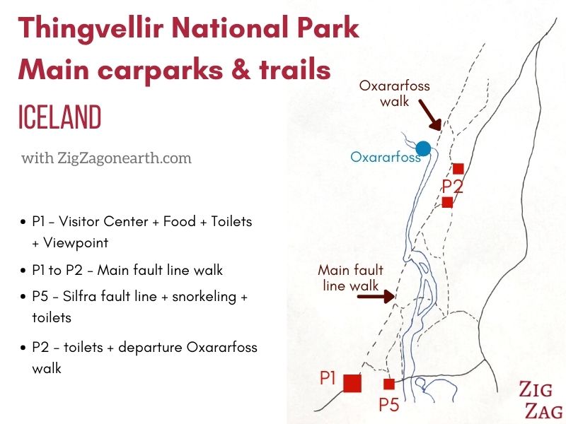
Thingvellir main carparks and trails – Map
Below is a simplified map of the main area of Thingevellir with the top 3 carparks and the walking paths and trails:
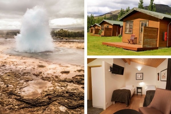
Where to stay near Thingvellir – accommodations
There are no hotels or B&Bs right in the National Park. But you can find nice options South of the lake and on the Golden circle.
You can stay very close to the geyser area – see options
Or you can have a look at the best rated accommodations on the Golden Circle
More tips in my article about the best places to stay in Iceland
STOP 1 – Hakid Viewpoint
So you can park at P1 and enjoy the Hakid viewpoint.
From there you can see:
- The fissures from above
- The house and church in the distance
- Thingvallavatn, the largest natural lake in Iceland with a surface of 84km2 (and a deepest point at 114m)
It is a perfect location to watch at sunrise.

STOP 2 – Main Thingvellir walk (P1 to P2) in Almannagja fault line
The main walk in Thingvellir is between the P1 and P2 carparks.
It is 1km long and made of gravel. It is downhill from P1 and then flat to P2 (and uphill on the return if you left your car at P1).
This path is maintained by the National Park.
If starting in P1, you first enter a path between 2 walls. It is really cool. Look at the rocks and the cracks!
On this path is where you can really stand between 2 rock walls, the narrowest area which is easily accessed in the Almannagja canyon.

Almannagja is one of the largest fault lines in the area. Cars used to go down through it.
After a while the scenery opens to the right and only the left wall of rocks remains (if walking towards P2).

The Almannagja canyon geology:
This is an eruptive belt and an earthquake zone. As the tectonic plates move, new earth crust is formed that accumulates at the fault edges (therefore the oldest rocks are far away from it on the East and West fjords).
It is part of an active volcanic region that extends to the Langjökull glacier.
Thingvellir is 7km wide between the Almannagjá and Heiðargjá faults. It is covered with 10,000 year-old lava..
Since the lava flow, the rift has been of about 70 metres.
Along the path
Along this path you can see a few detours with really short trails to see and learn about specific points:
- Lögberg viewpoint –
From this viewing platform you have a better view of the Summer House of the Prime minister.
At the viewpoint you can get explanation about Lögberg also knows as the “Law Rock”. This is where the Law Speaker proclaimed the laws of the Commonwealth out loud. According to the official website, he memorized them all and had 3 years to recite them all. This is also where speeches were given and where news of significant events were reported. - Drekkingarhylur –
Further down towards P2, you reach the area of Drekkingarhylur, “the drowning pool”
It is really pretty when the water is rushing
STOP 3 – Öxarárfoss waterfall
Oxararfoss waterfall trail
There is an easy pathway leaving from P2. It go up a little and then enter the Almannagja fault line.
From there it is an easy walk on boards to the waterfall.

The Thingvellir waterfall – Oxararfoss
The river Oxara lows through the Thingsvellir national park. One attraction is the small Öxarárfoss waterfall, which can be accessed after a short walk from the parking area on the eastern end of the fault line. Some people say it was artificially created because of a water diversion several centuries ago to provide better access to drinking water for the assemblies.
It is a small (20m high) and not so powerful waterfall by Icelandic standards but I enjoyed its rocks at the base and the surrounding of the canyon. Best light for photography is in the morning.
It is one of the 21 favorite Icelandic waterfalls.

Almannagja Canyon
The rift valley narrows from about 20-25 km in the NE to about 10 km in the SW. Its walls are moving apart of about 7 mm per year. The bottom is sinking about 1mm per year. The last major earthquake occurred in 1789.
From the waterfall you see another section fo the Almannagjá, canyon, but you cannot walk through it.

STOP 4 – Thingvellir Church
The church in Thingvellir is open during the day from May to September.
The current church dates back to 1859. Its Icelandic name is Thingvallakirkja. Small, with wooden decor, it is a nice short stop between walks in the fault lines.

I don’t drink coffee 

But I also like other drinks and sweets!
Do you like the free content you find on my blog? All my tips and practical information, without intrusive advertising…

STOP 5 – Snorkeling in the Silfra Fissure
One of the most famous activities in the National park and in all of Iceland, is to dive or snorkel in the Silfra fissure. A unique experience in Crystal clear waters.
You should book the activity in advance, as spots are limited. They provide all the necessary equipment. Book your spot

Sadly, I have not done it, but people rave about the experience the transparence of the water and the surreal feeling.
STOP 6 – Thingvellir Lake (Thingvallavatn)
At the South end of the Thingvellir fault lines is a large lake.
Thingvallavatn is the largest natural lake in Iceland with a surface of 84km2. Its deepest point is 114m. Part of the lake is included in the National park.
Below is the view from the Hakid viewpoint – but you can walk to the shore of the lake from P5 or P1.

Thingvellir in Winter
The National park remains accessible in Winter. The main path between the carparks P1 and P2 is maintained for people to easily walk through it.
Learn more on my article about Thingvellir in Winter.

Want to see other highlights in the area?
- The geothermal area of Haukadalur and its geysers – read article
- The powerful waterfall of Gullfoss – read article
- Or read my article about the Golden Circle
- And after the Golden circle, you can head to the South Coast with the waterfalls of Seljalandsfoss (read article) and Skogafoss (read article)
- Where to stay in Reykjavik: see my selection of best hotels.
Planning a trip to Iceland?
Check out my travel guide to help you plan:
Plan your dream trip in Iceland thanks to my guide
- 8 maps to easily plan your itinerary
- 100+ pre-selected locations
- GPS coordinates direct to the carparks
- Tips to make the most of your time
- 130+ original photos to help you choose
And keep track of your own trip!

Want to see more of Iceland’s beauty?
PREVIOUS LOCATION:
NEXT LOCATION:

Inspired? Share it on your favorite platform!


