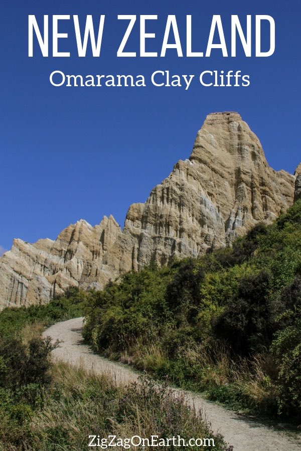
One of my favorite memories in New Zealand was visiting the Omarama Clay Cliffs. The sharp colorful pinnacles are a fascinating geological formation. And you can get inside it! Below is my complete guide to help you plan your visit: how to get there, walk, cost… with lots of photos!
Why visit the Omarama clay cliffs in New Zealand?
The Omarama clay cliffs are one of my favorite geological features and one of my favorite landscapes in New Zealand (and that is saying something considering some of the incredible places you can find there!).
The main reasons to visit the cliffs are:
- The impressive wall of sharp pinnacles
- The variety of colors from white to brown making them look like they are painted (contrary to the Putangirua pinnacles)
- The fact that they is located not far from the famous Lake Pukaki and Mount Cook, yet they are still a little off the beaten path thanks to the private land and unsealed road
- The fact that you can walk in between some of those giant pinnacles
- And the views of the Mackenzie Basin from the walking track

Omarama cliffs in video
It is not very well-known, but I think it is one of the best places to visit in South island. Let me show you in a short video what the walk around the pinnacles look like. You will better see what I am talking about:
Omarama clay cliffs and Lord of the Rings…
However the location is not as hidden as it used to be when it was only listed in NZ Frenzy E17. It is now more and more well-known and listed in several guides.
I met people asking if this was one of the filming locations of Lord of the Rings. I have not found any information in that regards.
All I can see are articles saying it was featured but nobody is writing in which scene.
All I have found are the other pinnacles on North island (Putangirua pinnacles) which were used as Dimholt Road in the ‘path of the dead’ scene.
Planning tips – Omarama Clay Cliffs New Zealand
Omarama Clay Cliffs location
- Located in the heart of South island, around Lake Pukaki
- Closest town = Omarama
- Queenstown to Omarama clay cliffs = 2h30 drive
- Mt Cook village to Omarama clay cliffs = 1h20 drive
- Christchurch to Omarama clay cliffs = 4h drive
The Omarama clay cliffs ( included in my eBooks, to help you plan an unforgettable road trip:
Plan your dream trip to New Zealand with my guides!
- 12 easy-to-plan maps
- 200+ pre-selected locations
- GPS coordinates
- Useful planning tips
- 285+ large photos
- 6 easy-to-plan maps
- 110+ pre-selected locations
- GPS coordinates
- Useful planning tips
- 190+ large photos
How to get to Omarama Clay Cliffs location
The next section is giving you more details on the road to get there but as an overview:
- It is off the main highway Road 8 between Pukaki and Omarama
- The site is well indicated via Quailburn road and then Henburn road – you will see big signs
- The last 7km are unsealed and some sections are quite bumpy so drive slowly
- There is a large carpark on arrival
- And then the walking path is well indicated
- If you don’t have time to walk there, don’t drive too fast on highway 8 as you can see the cliffs from the distance

Need to rent a car in New Zealand?
My tips:
- Compare prices on my favorite platform: Discovercars.com – one of the best rated comparison sites!
- Prefer a car with enough power for the mountain areas
- Consider their full coverage option – it for peace of mind!
- Book early to have a large choice of vehicles!
- See all my tips to choose and book your car


Visiting the Clay cliffs of Omarama
- Price = 5 dollars in the donation box. It is quite cheap for maintaining the dirt road and the path (this is private land!)
- Omarama clay cliffs closure – since it is on private land, I can’t ensure access remains open. You could find the road closed but you would know quickly off the main road so this is not a problem.
- I did not see any opening hours on the signs
- Camping is not allowed
- Wear sturdy shoes – the walk is uphill and at the end to enter the cliffs the path gets slippery and unstable
- Best light in the morning
- 10 to 15min walk uphill to the furthest area
Accommodations near the clay cliffs
The cliffs are an easy stop when you are leaving or arriving at the Lake Pukaki region. So this is more a general question of where to stay in the area of Lake Pukaki.
- The town of Omarama is quite small but well located at the intersection of Highways 8 and 83 and famous for its hot tubs
See the accommodations in Omarama - The town of Twizel, close to Lake Pukaki, is very central to many activities – I stayed at the Mountain Chalet Motel and the mountains huts were really practical with kitchen, carpark and easy access
Check out photos, prices and availabilities - But if I had known before, I would have stayed at Lake Ohau – if you want a peaceful environment with stunning nature, this the the place to go. But there are not many accommodation options. It is a small detour but I would have loved to spend a night there, for example at The Barn at Killin B&B.
Check out photos, prices and availabilities - Mt Cook village at the other end of Lake Pukaki is best for those who want to to do some hiking to the glaciers
Check out accommodations at Mt Cook

Drive to the Omarama Cliffs
The turn from Highway 8 for the Clay Cliffs is well indicated.
You start with 3km of a good sealed road – it is Quailburn Road.

Then you turn into Henburn road for 3km of good easy straight gravel road. Nothing difficult.
And you arrive at the turn where you enter private land. Once again it well indicated.
There is a small white box where you can pay your 5 dollar fee per car. There is nobody to check but please be honest. They are offering a service by maintaining the access gravel road and the walking path so they should be compensated.


The next section of the gravel road is not as good. It lasts for 4km.
It is quite bumpy and some people are driving really fast. But there is not that much traffic so slow down and take your time.
Make sure you have taken window damage insurance when renting your car.
Don’t forget to drive on the left!

And for the last kilometer you can see the magnificent cliffs appearing in front of you. This is really enjoyable. But don’t switch lane, keep driving left !!!! LOL

At the end of the road there is a large flat carpark. This is really well organized.
The walking path used to be an opened 4WD track.
But now the Omarama Clay cliffs track is closed to 4WD. You can only go on foot, which is great because the walk is wonderful (see in the next section).

I don’t drink coffee 

But I also like other drinks and sweets!
Do you like the free content you find on my blog? All my tips and practical information, without intrusive advertising…

Walk to the Omarama clay cliffs NZ
At the end of the carpark, the trail starts.
You can’t miss it 🙂
As I said, it used to be a 4WD track so it is quite wide and smoothed.
The walk is technically easy but uphill.

All the way along the walk you have views of the sharp pinnacles of Omarama on one side and the Mackenzie Basin on the other.

At the bottom flows the Ahuriri river.

You get to see the pinnacles from different angles with the stripes of colors and wave-like shapes.
Avoid the end of the afternoon as you would have the sun behind the cliffs.


Towards the end of the track you can go inside the pinnacles. This is where the walk is a little more difficult.
As you can see in the picture below it gets narrow with rocks.
It is slippery and a little steeper. But this is not for long. It is just to go inside and see the pinnacles up-close.

It will take you 10 to 15min walk uphill to reach this furthest area of the track.
Inside the sharp Omarama Pinnacles
I don’t know what I prefer: the view from the track or the view from inside.
From the track you can enjoy more the colors and have the impression of a wall.
While inside you get to appreciate the height and the steepness of the walls.


Once you enter, it is like a small amphitheater with sharp pinnacles all around:


Geology of the Clay cliffs of Omarama
If you are interested in understanding a bit more about how such a wonderful landscape was formed, here are a few facts if I understood correctly what I read:
- The cliffs were formed about 2 million years ago
- They are layers of deposits (gravel and silts) made by the rivers 2 million years ago (have a look at the walls where you get up close)
- The Ostler Fault runs through the region lifting this sediments
- And natural erosion created the ravines and shaped the pinnacles (and continue to do so) as the material is not strong


Other track
Most people stay on the main track and go inside the amphitheater.
But as I walked down I noticed a smaller track going up near the carpark.

I decided to take it. It is quite short and goes to another section where it looks a lot less like Pinnacles and more like a mini-mountain range.

More geological points of interest in the region
If you love geology and rock formations as much as I do, consider the following attractions a short drive from Omarama.
Drive up to the Lindis Pass

West of Omarama on highway 8 to Wanaka, you can drive up to the magnificent Lindis pass.
It is at an elevation of 981m.
Walking among the Elephant Rocks

South of Omarama, off road 83 you can follow the Vanishing world trail starting in Duntroon. It will lead you to geological wonders, fossils and ancient Maori drawings.
The most famous stop of the trail near Duntroon is the field of the Elephant Rocks. You can walk on this private land filled with giant rock formations. Those are yellow-brown Otekaike limestone. Lime accumulated around 25 million years ago. Sediments were hardened into limestone. As the land was uplifted just a few millions years ago, erosion cut through and revealed this natural sculptures.
Bring closed shoes (this is a farm with many cows and cow droppings…)
The other pinnacles of New Zealand
If you are into pinnacles and are visiting North island, you can also discover the Putangirua Pinnacles.
It is a completely different experiences.
This access is a lot more difficult since you walk in the river bed.
The pinnacles are taller but not as colorful.
Learn more in my article

Want to see more of NEW ZEALAND?
PREVIOUS:
Things to do around Lake Pukaki New Zealand
NEXT:

Do you enjoy such geological formations?


